| Bridge Team work | Weather Routeing |
Maintain a
Safe Navigational Watch
Weather Routeing
Principle
of Weather Routeing
Introduction
Ship weather routing helps to develop the
most efficient track for ocean voyages based on forecasts of:
Weather,
Sea conditions, and
The ship’s
individual characteristics for a particular transit.
Within specified limits of weather and sea
conditions, the most efficient is used to mean:
Maximum safety and
Crew comfort,
Minimum fuel consumption,
Minimum time underway, or
Any of one of
the above or a mixture of the above factors.
The mariner’s first resources for route
planning in relation to weather are the routeing charts and the sailing
directions.
These publications give climatic data,
such as wave height frequencies and ice limits, for the major ocean seas of the
world.
They recommend specific routes based on
probabilities, but not on specific conditions.
A ship routing agency, acting in an
advisory service, attempts to avoid or reduce the effects of specific adverse
weather and sea conditions by issuing:
Initial route recommendations prior to
sailing
Recommendations for track changes while
underway (diversions), and
Weather
advisories to alert the master about approaching unfavorable weather and sea
conditions which cannot be effectively avoided by a diversion.
The initial route recommendation is based
on a survey of weather and sea forecasts between the point of departure and the
destination.
It takes into account the hull type, speed
capability, cargo, and loading conditions. The ship’s progress is continually
monitored, and, if adverse weather and sea conditions are forecast along the
ship’s current track, a recommendation for a diversion or weather advisory is
transmitted to the ship.
By this process of initial route selection
and continued monitoring of the ship’s progress for possible changes in the
forecast weather and sea conditions along a route, it is possible to maximize
the ship’s speed and safety.
The greatest potential advantage for this
ship weather routing exists when:
(1)The passage is relatively long, about
1,500 miles or more;
(2)The waters are navigationally
unrestricted, so that there is a choice of routes;
and
(3)Weather is a factor in determining the
route to be followed.
Use of this advisory service in no way
relieves the master of responsibility for prudent seamanship and safe
navigation.
There is no intent by the routing agency
to inhibit the exercise of professional judgment and prerogatives of masters.
Why
& How of Weather Routeing
The advent of extended range forecasting
and the development of selective climatology, along with powerful computer
modeling techniques, have made ship routing systems possible.
The short-range dynamic forecasts of 3 to
5 days are derived from meteorological equations.
These forecasts are computed twice daily
from a data base of northern hemisphere surface and upper air observations, and
include surface pressure, upper air constant pressure heights, and the spectral
wave values.
A significant increase in data input,
particularly from satellite information over ocean areas, can extend the time
period for which these forecasts are useful.
For extended range forecasting, generally
3 to 14 days, a computer searches a library of historical northern hemisphere
surface pressure and 500 millibar analyses for an analogous weather pattern.
This is an attempt at selective
climatology by matching the current weather pattern with past weather patterns
and providing a logical sequence of events forecast for the 10 to 14 day period
following the dynamic forecast.
It is performed for both the
For longer ocean transits, monthly values
of wind, seas, fog, and ocean currents are used to further extend the time
range.
Automation has enabled ship routing
agencies to develop realistic minimum time tracks. Computation of minimum time
tracks makes use of:
1. A navigation system to compute route
distance, time enroute, estimated times of arrival (ETA’s), and to provide 6
hourly DR synoptic positions for the range of the dynamic forecasts for the
ship’s current track.
2. A surveillance system to survey wind,
seas, fog, and ocean currents obtained from the dynamic and climatological
fields.
3. An environmental constraint system
imposed as part of the route selection and surveillance process. Constraints
are the upper limits of wind and seas desired for the transit. They are
determined by the ship’s loading, speed capability, and vulnerability.
The constraint system is an important part
of the route selection process and acts as a warning system when the weather
and sea forecast along the present track exceeds predetermined limits.
4. Ship speed characteristics used to
approximate ship’s speed of advance towards the destination while transiting
the forecast sea states.
There
are two general types of commercial ship routing services.
The first uses computer simulations and
analyses these into direct forecast conditions and routing recommendations.
The second assembles and processes weather
and sea condition data and transmits this to ships at sea for on-board
processing and generation of route recommendations.
The 1st system allows for
greater computer power to be applied to the routing task because powerful computers
are available ashore.
The 2nd system allows greater
flexibility to the ship’s master in changing parameters, selecting routes, and
displaying data.
Ship
and cargo as a factor
Ship and cargo characteristics have a
significant influence on the application of ship weather routing.
Ship
size,
Speed
capability, and
Type
of cargo is an important considerations in the route
selection process prior to sailing and the surveillance procedure while
underway.
A ship’s characteristics identify its
vulnerability to adverse conditions and its ability to avoid them.
Generally, ships with higher speed
capability and less cargo encumbrances will have shorter routes and be better
able to maintain near normal speed of advance towards the destination’s
than ships with lower speed capability or cargoes.
Some routes are unique because of the type
of ship or cargo.
Avoiding one element of weather to reduce
pounding or rolling may be of prime importance.
For example, a 20 knot ship with a heavy
deck cargo may be severely hampered in its ability to maintain a 20 knot speed
of advance towards the destination in any seas exceeding moderate head or beam
seas because of the possibility of damage resulting from the deck load’s
characteristics.
A similar ship with a stable cargo under
the deck is not as vulnerable and may be able to maintain the 20-knot speed of
advance towards the destination in conditions, which would drastically slow the
deck-loaded vessel.
In towing operations, a tug is more
vulnerable to adverse weather and sea conditions, not only in consideration of
the tow, but also because of its already limited speed capability. Its slow
speed adds to the difficulty of avoiding adverse weather and sea conditions.
Ship performance curves (speed curves) are
used to estimate the ship’s speed of advance towards the destination while
transiting the forecast sea areas.
The curves indicate the effect of head,
beam, and following seas of various significant wave heights on the ship’s
speed.
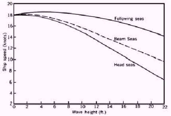
A
performance curve prepared for an 18-knot vessel
With the speed curves it is possible to
determine just how costly a diversion will be in terms of the required distance
and time.
A diversion may not be necessary where the
duration of the adverse conditions is limited.
In this case, it may be better to ride out
the weather and seas knowing that a diversion, even if able to maintain the
normal speed of advance towards the destination, will not overcome the
increased distance and time required.
At other times, the diversion track is less
costly because it avoids an area of adverse weather and sea conditions, while
being able to maintain normal speed of advance towards the destination even
though the distance to destination is increased.
Although speed performance curves are an
aid to the ship routing agency, the response by mariners to deteriorating
weather and sea conditions is not uniform.
Some reduce speed voluntarily or change
heading sooner than others when unfavorable conditions are encountered.
Certain waves
with characteristics such that the ship’s bow and stern are in successive
crests and troughs present special problems for the mariner.
Being nearly equal to the ship’s length,
such wavelengths may induce very dangerous stresses.
The degree of hogging and sagging and the associated
danger may be more apparent to the mariner than to the ship routing agency.
Therefore, the master may initiate
adjustment in course and speed for a more favorable ride when this situation is
encountered.
Weather
- Wind
Environmental factors of importance to
ship weather routing are those elements of the atmosphere and ocean that may
produce a change in the status of a ship transit.
In ship routing, consideration is given to
wind, seas, fog, ice, and ocean currents. While all of
the environmental factors are important for route selection and surveillance, optimum
routing is normally considered attained if the effects of wind and seas can be
optimized.
The effect of wind speed on ship
performance is difficult to determine.
In light winds (less than 20-knots), ships
lose speed in headwinds and gain speed slightly in following winds.
For higher wind speeds, ship speed is
reduced in both head and following winds.
This is due to the increased wave action,
which even in following seas results in increased drag from steering
corrections, and indicates the importance of sea conditions in determining ship
performance.
In dealing with wind, it is also necessary
to know the ship’s sail area.
High winds will have a greater adverse
effect on a large, fully loaded container ship or car carrier than a fully
loaded tanker of similar length.
This effect is most noticeable when
docking, but the effect of beam winds over several days at sea can also be
considerable.
Weather
- Wave height
Wave height is the major factor affecting
ship performance.
Wave action is responsible for ship
motions, which reduce propeller thrust, and cause increased drag from steering
corrections.
The relationship of ship speed to wave
direction and height is similar to that of wind.
“increased drag
from steering corrections”
This happens because the course steered is
not uniform, the auto pilot keeps correcting the course steered too frequently
as such, instead of a steady course the ship steers a course that is slightly
off on either side of the course.
Vessels speed remaining the same the speed
towards the destination suffers.
Head seas reduce ship speed, while
following seas increase ship speed slightly to a certain point, beyond which
they retard it. In heavy seas, exact performance may be difficult to predict
because of the adjustments to course and speed for ship handling and comfort.
Although the effect of sea and swell is much greater than wind, it is difficult
to separate the two in ship routing
Weather
- Fog
Fog, while not directly affecting ship
performance, should be avoided as much as possible, in order to maintain normal
speed in safe conditions.
Extensive areas of fog during summertime
can be avoided by selecting a lower latitude route than one based solely upon
wind and seas.
Although the route may be longer, transit
time may be less due to not having to reduce speed in reduced visibility.
In addition, crew fatigue due to increased
watch keeping vigilance can be reduced.
Weather
- Abnormal Waves
During the northern hemisphere autumn and
winter, the waters to the north of the gulf stream in the north Atlantic are at
their coldest, while the gulf stream itself remains at a constant relatively
warm temperature.
After passage of a strong cold front or
behind a developing coastal low pressure system, arctic air is sometimes drawn
off the mid-Atlantic coast of the united states and out over the warm waters of
the gulf stream by northerly winds. This cold air is warmed as it passes over
the
Higher waves and confused seas result from
these winds. When these winds oppose the northeast set of the current, the
result is increased wave heights and a shortening of the wave period. If the
opposing current is sufficiently strong, the waves will break. These phenomena
are collectively called the “north wall effect,” referring to the region of
most dramatic temperature change between the cold water to the north and the warm
The most dangerous aspect of this
phenomenon is that the strong winds and extremely high, steep waves occur in a
limited area and may develop without warning. Thus, a ship that is laboring in
near-gale force northerly winds and rough seas, proceeding on a northerly
course, can suddenly encounter storm force winds and dangerously high breaking
seas.
Numerous ships have foundered off the
North American coast in the approximate position of the Gulf Stream’s north
wall.
A similar phenomenon occurs in the North
Pacific near the Kuroshio Current and off the
southeast African coast near the Agulhas current.
Ocean
currents
Ocean currents do not present a
significant routing problem, but they can be a determining factor in route
selection and diversion.
This is especially true when the points of
departure and destination are at relatively low latitudes.
The important considerations to be
evaluated are the difference in distance between a great-circle route and a
route selected for optimum current, with the expected increase in speed of
advance towards the destination from the following current, and the decreased
probability of a diversion for weather and seas at the lower latitude.
Direction and speed of ocean currents are
more predictable than wind and seas, but some variability can be expected.
Major ocean currents can be disrupted for
several days by very intense weather systems such as hurricanes and by global
phenomena such as the ocean current originating off the West coast of S.
America known as EL NINO.
Ice
The problem of ice is twofold:
Floating
ice (icebergs) and
Deck ice.
If possible, areas of icebergs or pack ice
should be avoided because of the difficulty of detection and the potential for
collision.
Deck ice may be more difficult to contend
with from a ship routing point of view because it is caused by freezing weather
associated with a large weather system.
While mostly a nuisance factor on large
ships, it causes significant problems with the stability of small ships.
Latitude
Generally, the higher the latitude of a
route, even in the summer, the greater is the problems with the weather.
Ships, which are not capable of handling
bad weather – like tows, should avoid latitudes in excess of
40°especially during the non-summer months.
Weather
Patterns
A ship routing should avoid seas
associated with extra tropical low-pressure systems in the mid and higher
latitudes and the tropical systems in low latitude.
Seasonal or monsoon weather is also a
factor in route selection and diversion in certain areas.
Low-pressure systems though not a severe
problem for most ships however, may generate prolonged periods of rough seas,
which may hamper normal work aboard ship.
Relatively small ships, tugs with tows,
low powered ships, and ships with sensitive cargoes can be significantly
affected by weather systems weaker than gale intensity.
Using a routing agency can be beneficial.
Gales and storms in the open sea can
generate very rough or high seas, particularly with an adverse ocean current.
This can force a reduction in speed in
order to gain a more comfortable and safe ride.
But because of the extensive area covered
by these low-pressure systems, once ship’s speed is reduced the ability to get
away from these areas is also reduced.
Thus, exposure to potential damage and
danger is greatly increased.
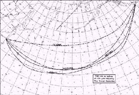
Generalized 10% frequency Isolines
of gale force winds for October through January.
Weather
Patterns
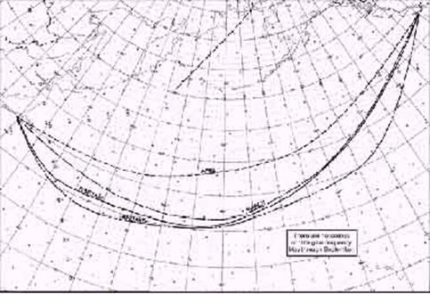
Generalized 10% frequency Isolines of gale force winds for January through April..
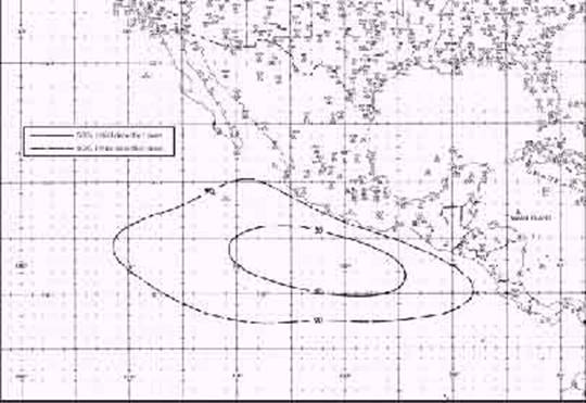
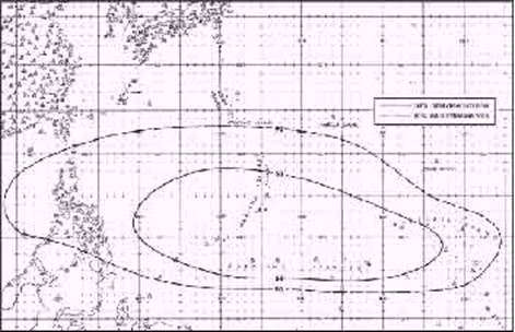
Area of initial detection of high
percentage of tropical cyclones which later developed to tropical storm or
hurricane intensity, NA - 1957-1974.
Area of initial detection of high
percentage of tropical cyclones which later developed to tropical storm or
hurricane intensity, NA - 1946-1973
A recommendation for a diversion by a
routing agency well in advance of the intense weather and associated seas will
limit the duration of exposure of the ship.
If effective, ship speed will not be
reduced and satisfactory progress will be maintained even though the remaining
distance to destination is increased.
Overall transit time is usually shorter
than if no track change had been made and the ship had remained in heavy
weather.
In some cases diversions are made to avoid
adverse weather conditions and shorten the track at the same time.
Significant savings in time and costs can
result.
In very intense low-pressure systems, with
high winds and long duration over a long fetch, seas will be generated and
propagated as swell over considerable distances. Even on a diversion, it is
difficult to effectively avoid all unfavorable conditions.
The areas, seasons, and the probability of
development of tropical cyclones are fairly well defined in climatological
publications.
In long range planning, considerable
benefit can be gained by limiting the exposure to the potential hazards of
tropical systems.
However, when transiting the tropical
cyclone generating area, a ship under routing may provide the first report of
environmental conditions indicating that a new disturbance is developing.
Thus a reverse case of information flows.
Of course, avoiding an existing tropical
cyclone takes precedence over avoiding a general area of potential development.
It has proven equally beneficial to employ
similar considerations for routing in the monsoon areas of the Indian Ocean and
the South China Sea.
This is accomplished by providing routes
and diversions that generally avoid the areas of high frequency of gale force
winds and associated heavy seas, as much as feasible.
Ships can then remain in satisfactory
conditions with limited increases in route distance.
Seasonal
Isolated Weather
In addition to the synoptic weather
considerations in ship weather routing, there are special isolated problems
that can be avoided by following recommendations and advisories of ship routing
agencies.
These problems generally cover smaller
areas and are seasonal in nature, but are still important to ship routing.
In the north Atlantic, because of heavy
shipping traffic, frequent poor visibility in rain or fog, and restricted
navigation, particularly east of Dover strait, some mariners prefer to transit
to or from the North Sea via Pentland firth, passing
north of the British isles rather than via the English channel.
Weather routed ships generally avoid the
area of dense fog with low visibility in the vicinity of the grand banks off
Newfoundland and the area east of Japan north of 35°N.
Icebergs are a definite hazard in the North
Atlantic from late February through June, and occasionally later.
The hazard of floating ice is frequently
combined with restricted visibility in fog.
International ice patrol reports and
warnings are incorporated into the planning of routes to safely avoid dangerous
iceberg areas.
It is usually necessary to hold south of
at least 45°n until well southeast of Newfoundland.
In winter, other seasonal wind systems
include Pampero, mistral, and bora, which are best
avoided.
In the summer, the semi-permanent
high-pressure systems over the world’s oceans produce strong equator ward flow
along the west coasts of continents.
This feature is most pronounced off the
coast of
Routeing
Advice
An initial route recommendation is issued
to a ship normally 48 to 72 hours prior to sailing, and the process of
surveillance begins.
Surveillance is a continuous process,
maintained until the ship arrives at its destination.
Initial route recommendations are a
composite representation of experience, climatology, weather and sea state
forecasts, operational concerns, and the ship’s seagoing characteristics.
A planning route provides a best estimate
of a realistic route for a specific transit period.
Such routes are provided when estimated
dates of departure are given to the routing agency well in advance of
departure, usually a week to several months.
Long- range planning routes are based more
on seasonal and climatological expectations than the current weather situation.
While planning routes is an attempt to make
extended range (more than a week) or long range (more than a month) forecasts,
these recommendations are likely to be revised near the time of departure to
reflect the current weather pattern.
An initial route recommendation is more
closely related to the current weather patterns by using the latest dynamic
forecasts than are the planning route recommendations.
These, too, are subject to revision prior
to sailing, if weather and sea conditions warrant.
Departure
A Departure advice is a recommendation for
delay in departure, or early departure if possible, and is intended to avoid or
significantly reduce the adverse weather and seas forecast on the first portion
of the route, if sailing on the original departure date.
The initial route is not revised, only the
timing of the ship’s transit through an area with currently unfavorable weather
conditions.
Adjusting the departure time is an
effective method of avoiding a potentially hazardous situation where there is
no optimum route for sailing at the originally scheduled time.
Diversion
A diversion is an underway adjustment in
track and is intended to avoid or limit the effect of adverse weather
conditions forecast to be encountered along the ship’s current track.
Ship’s speed generally is reduced by the
encounter with the heavy weather.
In most cases the distance to destination
is increased in attempting to avoid the adverse weather, but this is partially
overcome by being able to maintain near normal speed of advance towards the
destination.
Diversions are also recommended where
satisfactory weather and sea conditions are forecast on a shorter track.
Speed
of advance towards the destination
Adjustment of speed of advance towards the
destination is a recommendation for slowing or increasing the ship’s speed as
much as practicable, in an attempt to avoid an adverse weather situation by
adjusting the timing of the encounter.
This is also an effective means of
maintaining maximum ship operating efficiency, while not diverting from the
present ship’s track.
By adjusting the speed of advance towards
the destination, a major weather system can sometimes be avoided with no
increase in distance.
The development of fast ships gives the
ship routing agency the potential to “make the ship’s weather” by adjusting the
ship’s speed and track for encounter with favorable weather conditions.
Evading
Bad weather
Evasion is a recommendation to the master
to take independent action to avoid, as much as possible, a potentially
dangerous weather system.
The ship routing meteorologist may
recommend a general direction for safe evasion but does not specify an exact
track.
The recommendation for evasion is an
indication that the weather and sea conditions have deteriorated to a point
where ship handling and safety are the primary considerations and progress
toward destination has been temporarily suspended, or is at least of secondary
consideration.
Weather
Notices
Weather advisory is a transmission sent to
the ship advising the master of expected adverse conditions, their duration,
and geographic extent.
It is initiated by the ship routing agency
as a service and an aid to the ship.
The best example of a situation for which
a forecast is helpful is when the ship is currently in good weather but adverse
weather is expected within 24 hours for which a diversion has not been
recommended, or a diversion where adverse weather conditions are still
expected.
This type of advisory may include a
synoptic weather discussion, and a wind, seas, or fog forecast.
The ability of the routing agency to
achieve optimum conditions for the ship is aided by the master adjusting course
and speed where necessary for an efficient and safe ride.
At times, the local sea conditions may
dictate that the master takes independent action.
Routeing
for Southern hemisphere
Available data on which to base analyses
and forecasts is generally very limited in the southern hemisphere. Weather and
other environmental information obtained from satellites offers the possibility
of improvement in southern hemisphere forecast products.
Passages south of the
In particular, near the southeast coasts
of Africa and South America, intense low-pressure systems form in the lee of
relatively high terrain near the coasts of both continents.
Winter transits south of cape horn are difficult, since the time required for transit
is longer than the typical interval between storms.
Remaining equator ward of about 35°s as
much as practicable will limit exposure to adverse conditions.
If the frequency of lows passing these
areas is once every three or four days, the probability of encountering heavy
weather is high.
Tropical cyclones in the southern
hemisphere present a significant problem because of the sparse surface and
upper air observations from which forecasts can be made.
Satellites provide the most reliable means
by which to obtain accurate positions of tropical systems, and also give the
first indication of tropical cyclone formation.
In the southern hemisphere, ship weather
routing services is available, but are limited in application because of sparse
data reports, from which reliable short and extended range forecasts can be
produced.
Strong climatological consideration is
usually given to any proposed southern hemisphere transit.
Communications
A vital part of a ship routing service is
communication between the ship and the routing agency. Reports from the ship
show the progress and ability to proceed in existing conditions.
Weather reports from the ship enrich the
basic data on which analyses are based and forecasts derived, assisting both
the reporting ship and others in the vicinity.
Benefits
The benefits of ship weather routing
services are primarily in cost reduction and safety.
The savings in operating costs are derived
from reductions in transit time, heavy weather encounters, fuel consumption,
cargo and hull damage, and more efficient scheduling of dockside activities.
The savings are further increased by fewer
emergency repairs, more efficient use of personnel, improved topside working
conditions, lower insurance rates as preferred risks under weather routing, and
ultimately, extended ship operating life.
An effective routing service maximizes
safety by greatly reducing the probability of severe or catastrophic damage to
the ship, and injury of crewmembers. Avoiding heavy weather also enhances the
efficiency and health of the crew.
This is especially important on modern,
automated ships with reduced crews.
Conclusion
The success of ship weather routing is
dependent upon the validity of the forecasts and the routing agency’s ability
to make appropriate route recommendations and diversions.
Modern ship designs, exotic cargoes, and
sophisticated transport methods require individual attention to each ship’s
areas of vulnerability.
Any improvement in the description of sea
conditions by ocean wave models will improve the output from ship routing and
sea keeping systems.
Advanced planning of a proposed transit,
combined with the study of expected weather conditions, both before and during
the voyage, as is done by ship routing agencies, and careful on board attention
to sea keeping (with instrumentation if available) provide the greatest
opportunity to achieve the goal of optimum environmental conditions for ocean
transit.