| Wind Pressure Sys. | Structure of a Depression | Anticyclone | Weather Services | TRS |
Meteorology
Atmosphere and Atmospheric Pressure
The Atmosphere
Most of the weather changes take place in the lower
layer of the atmosphere, which is known as the TROPOSPHERE.
This layer extends about 11 miles-high over the
equatorial regions and about 5 miles high over the
The layer above the troposphere is known as the
STRATOSPHERE where there is little water vapour and the lower part appears to
be isothermal.
There is a rise in temperature towards its upper
limit.
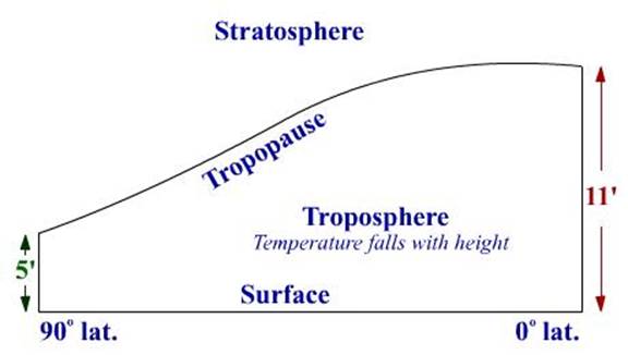
The boundary between the troposphere and the
stratosphere is known as the TROPOPAUSE.
About 20 miles above the earth the stratosphere gives
way to the OZONOSPHERE, where there is a high concentration of ozone which
absorbs ultra violet radiation.
The IONOSPHERE starts about 50 miles above the earth.
The density of the atmosphere decreases with height.
Approximate percentage volumes of the various gases
forming dry air in the troposphere are nitrogen 78%, oxygen 21%, argon 0.9%,
carbon dioxide 0.03%, with the balance being made up of traces of hydrogen,
helium, neon, krypton, radon, xenon and ozone.
As most of the weather changes take place in the
troposphere, it is in this region that the changes in temperature arc most
important.
As altitude increases, air pressure decreases due to
the decreased weight of air above. With less pressure, the density decreases.
More than three-fourths of the air is concentrated within a layer averaging
about 7 statute miles thick, called the troposphere. This is the region of most
“weather,” as the term is commonly understood.
The top of the troposphere is marked by a thin
transition zone called the tropopause, immediately
above which is the stratosphere. Beyond this lie several other layers having
distinctive characteristics. The average height of the tropopause
ranges from about 5 miles or less at high latitudes to about 10 miles at low
latitudes.
Sun as energy source
The sun, at a distance of
about. 93,000,000 miles and at a temperature of about 6,000°C, is the
principal source of light and heat for the earth. The heat from the sun travels to the earth in
the form of short wave radiation, which passes through the atmosphere without
appreciably warming it.
On striking the earth some of the heat will be absorbed
to warm the earth. The heat received at
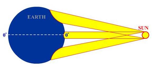
the earth from the sun is known as INSOLATION.
The amount of insolation per
unit area varies with latitude. It can
be seen in the sketch below that a band of rays has to heat a very much larger
area in a high latitude than it does in a low
latitude.
The increase in the temperature of the earth will
depend, amongst other things, on the amount of insolation
and the specific heat of the earth.
Assuming that the insolation
is constant, a surface with a high specific heat warms and cools les s quickly
than a surface with a low specific heat.
For instance, the sea temperature in non-tidal waters
hardly changes in the 24 hours.
A contributing factor to this small change is its
depth. It will be found that, in
general, sea temperatures are less than the temperatures of adjacent land by
day and greater by night. There is a
similar difference in summer and winter.
The amount of insolation
will depend on the sun’s altitude and the degree of cloud cover. It may be noted that the SOLAR CONSTANT,
which is the intensity of solar radiation at the outer boundary of the
atmosphere, is 1.39kw/m2.
The height of the station under consideration above
sea level will be a factor influencing the heating, as will the prevailing
wind. Air which his flowed over warm
surfaces will have a smaller cooling effect than air which has flowed over cold
surfaces.
As the earth is a warm body it radiates heat. This radiation will cool the surface.
If the earth is radiating heat at a greater rate than
it is receiving it, the net result will be a cooling of the surface. The converse is also true.
In the diagram below the curves of insolation
and radiation are shown to increase and decrease at a regular rate for case of
illustration.
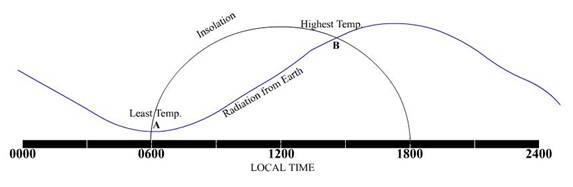
Quite clearly the temperature falls until point A is
reached when it begins to rise. The rise
continues to point B and then, once again, the temperature falls.
It will be noted that the lowest temperature occurs
shortly after sunrise whereas the maximum temperature occurs about 1400 hours
local time, and not when insolation is minimum and
maximum. A similar lag takes place on an
annual basis. In northern latitudes the
lowest temperatures do not usually occur until February and the maximum temperatures
occur in July and early August.
The sea temperature lags even further behind the
sun. The minimum
occurring in March and the maximum in September.
It must be understood that all the above general
statements can be considerably modified by local weather conditions,
particularly cloud amounts.
Nature of solar radiation
Heat is transferred to the air surrounding the Earth
by one or more of the following means: -
1. Radiation
2. Conduction
3. Convection
4. Turbulence.
1.
RADIATION.
The sun’s rays being in the shorter wavelength do not
appreciably heat up the air, rather the heating is done of the water vapour
particles in the atmosphere,
The sun does however heat the Earth, and the Earth
after getting heated up re-radiates heat. This earth heat is in the form of
long waves. If there is no cloud cover then the heat is transferred to space,
but with a cloud cover the heat is radiated back on the earth.
Thus on a cloudless night the heat radiated out by the
Earth is considerable and a lot of surface cooling takes place.
2. CONDUCTION.
The heat is transferred from particle to
particle. Thus, air, which is in contact
with a warm surface, is warmed; this occurs by day when the sun is
shining. Air, which is in contact with a
cold surface, is cooled; this occurs on clear nights.
Air masses acquire their characteristics by the same
process.
3. CONVECTION.
Air, which is warmed, expands and consequently
its density decreases. This makes it
lighter than the un-warmed air surrounding it and the warmer air rises.
Convectional processes take large amounts of warm air
and water vapour from the surface to the upper levels. When the water vapour condenses into water
drops and precipitation occurs, the latent heat remains. Most of the atmospheric heating takes place in
this way.
Conversely, air, which is colder than the surrounding
air, has a greater density, and as it is heavier, it sinks. An example of this is the Katabatic wind.
4. TURBULENCE.
Air, which flows over a rough
surface tends to be deflected upwards.
The Rising air will be replaced by some air from levels up to 600m
giving an interchange of air between the surface and 600m.
The rising air carries its warmth (acquired by
conduction) with it, and the falling brings its coolness.
LAPSE RATE
Increase of height above sea level generally means a
decrease of temperature. The rate at which the temperature changes with height
is known as the lapse rate, an average value being about 0.7°C/100m.
ENVIRONMENT LAPSE RATE
The lapse rate can vary and the environment lapse rate
will be referred to when a particular air mass is under consideration. This
rate will be dependent on many factors and will vary with the altitude,
although it is usually between the S.A.L.R. and D.A.L.R. Plotting temperatures
of the air at various heights will give environment curves.
ADIABATIC TEMPERATURE CHANGE
If a volume of air rises to a region of lower
pressure, the volume will increase and following the gas laws the temperature
of the volume will fall. The change of temperature is solely due to expansion
or contraction and no heat has been given to or received from the adjacent air.
This change of temperature is known as an Adiabatic Temperature Change.
DRY ADIABATIC LAPSE.RATE (D.A.L.R.).
When dry air is forced to rise it has been found that
it decreases its temperature by 1°C/100m and this is known as the Dry Adiabatic
Lapse Rate. With dry air, which is forced down, an increase at a similar rate
is found.
Dry air is any air, which is not saturated.
SATURATED ADIABATIC LAPSE
RATE (S.A.L.R.)
Latent heat is the heat necessary to change 1 kilogram
of water to 1 kilogram of Vapour at saturation temperature. If a quantity of water changes to vapour an
amount of latent heat will have been required.
This sort of thing will happen with air at a temperature
above dew point (note however that the higher the temperature of the air the
more water vapour it will normally contain- unless some artificial means have
been employed to reduce the water vapour content).
The latent heat that has been originally required to
change the water to its vapour state has not been lost but is retained in the
mass of the water vapour. Now when the water vapour is cooled and the water
condenses back the latent heat is released and this is known as the latent heat
of condensation.
The latent heat of vapourisation
is generally accepted as 540 calories/gramme of
water.
When the cooling of the air to its dew point
temperature is caused by the air rising the latent
heat released will modify the overall cooling rate.
For the air that is rising:
D.A.L.R. (-) 1.0°C/100m
Latent Heat (+)
0.5°C/100m (average for sea level in middle latitudes)
S.A.L.R. (-) 0.5°C/100m
The S.A.L.R. is a variable quantity depending on the
latent heat of the condensing water vapour. The S.A.L.R. is low near the
equator and high in
It will also increase with height.
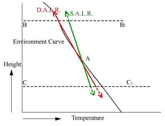
STABLE AIR.
If air,
which his been forced to rise (or fall) from its initial level tends to return
to that level it is said to be stable.
This condition occurs when the environment lapse rate is less than the
S.A.L.R.
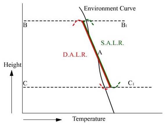
The figure shows in black the environment curve of
some tropical air, whose lapse rate is about 0.3°C/100m.
Suppose some dry air at point A is forced upwards, it
will cool at the D.A.L.R. and follow the red line.
When the rising air reaches the level BB1 it will be
much colder than the environment or surrounding air.
As it is colder it is denser, and will want to return
to A, a tendency shown by the dotted line.
If instead of the air rising from A, it fell, then at
the level CC, the failing air would have warmed adiabatically to a considerably
higher temperature than the environment or surrounding air.
It would then be less dense and the tendency would be
for it to return to A as indicated.
If the air forced to rise or fall from A were
saturated instead of dry, the path indicated by the green line would be
followed. Again, for the same reasons as
are given above, the tendency is for the air to return to A.
UNSTABLE AIR.
If air, which has been forced to rise (or fall) from
its initial level tends to continue its upward (or downward) movement, it is
said to be unstable. This condition occurs when the environment lapse rate is
greater than the D.A.L.R.
The figure shows in black the environment curve of
some polar air whose lapse rate is about 1.2°C/100m.
Suppose some saturated air at point A is forced upward
it will cool at the S.A.L.R. and follow the green line. When this rising air reaches the level BB1,
it will be warmer than the environment or surrounding air. As it is warmer it will be less dense and the
tendency is for it to continue upwards.
If, instead of the air rising from A, it fell, then at
the level CC1, the falling air would be at a lower temperature than the
environment or surrounding air. It would
then be denser and it would continue to fall.
If the air forced to rise or fill from A were dry
instead of saturated, the path indicated by the red line would be
followed. Again, for the reasons given
above, the rising or falling air continues to rise or fall.
NEUTRAL AIR.
This condition occurs when the environment lapse
rate is the same as the D.A.L.R., if dry air is under consideration, or
the. S.A.L.R. in the
case of saturated air. The air
which has been forced to rise or fall will have no tendency to continue its
upward or downward movement nor will it have any tendency to return to its
original position.
CONDITIONAL INSTABILITY.
This occurs
when stable conditions exist for dry air and unstable conditions exist when the
air is, saturated. The figure
illustrates this.
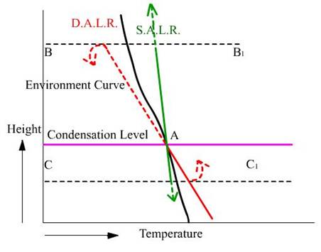
The
environment curve has a lapse rate between the S.A.L.R. and the D.A.L.R. The
red line representing dry air forced up or down follows a similar pattern to
earlier figure for stable air, whilst the green line representing saturated air
forced up or down follows a similar pattern to figure for unstable air.
This
conditionally unstable condition is quite common, the air below the
condensation level being stable and that above being unstable
TEMPERATURE INVERSION
The usual tendency for the temperature to fall
with height is sometimes reversed. When
the temperature increases with height an inversion is said to exist. An inversion also exists if a layer of air is
isothermal.
Inversions may occur at any level at all. They frequently, occur at ground level on
clear nights. They also occur just above
cloud layers.
As an inversion gives rise to very stable conditions,
convection and turbulence are damped out and there will be no upward movement
of air through the inversion.
Inversions may be caused in anticyclone
conditions by subsiding air warming adiabatically to a temperature above that
of the lower layers of air.
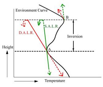
The figure
shows a curve for the environment where there is an inversion above the
surface.
Dry and
saturated air forced up from A will clearly return showing stable conditions,
whereas if forced up from B (or down from A) unstable conditions exist.
Atmospheric Pressure
The atmosphere by reason of its weight exerts a
pressure on the surface of the earth. This
pressure is normally measured in millibars, the mean
value at sea level being around 1013 mb.
This pressure is in certain places semi-permanently
above the mean, while in other places it is semi permanently below the
mean. These places are referred to as
regions of high and low pressure respectively.
There are also temporary areas of high or low pressure.