| Wind Pressure Sys. | Structure of a Depression | Anticyclone | Weather Services | TRS |
Meteorology
Structure of Depressions
DEPRESSIONS
A depression, also known for synoptic purposes as a
low, appears on a synoptic chart as a series of isobars roughly circular or
oval in shape, surrounding an area of low pressure. Depressions are frequent at
sea in middle latitudes and are responsible for most strong winds and unsettled
weather, though not all depressions are accompanied by strong winds.
Depressions vary much in size and depth. One may be
only 100 miles in diameter and another over 2,000; one may have a central
pressure of 960 millibars and another 1,000 millibars.
In the N (S) hemisphere the winds blow around an area
of low pressure in an anti-clockwise (clockwise) direction.
There is a slight inclination across the isobars
towards the lower pressure. The strength of the wind is closely related to the
gradient across the isobars, the closer the isobars the stronger the wind.
Depressions may move in any direction though many move
in an E direction, at speeds varying from nearly stationary to 40 knots.
Occasionally, during the most active stage of its existence, a low may move as
fast as 60 knots. Lows normally last around 4 to 6 days and slow down when
filling.
The following is a brief general description of
depressions and the associated weather in temperate or middle latitudes of the
two hemispheres. It must be emphasized,
however, that individual depressions in different localities differ
considerably from one another according to the temperature and humidity of the
air currents of which they are composed and the nature of the surface over
which they are traveling.
A falling barometer indicates the approach of a
depression.
In the N (S) hemisphere, if a depression is
approaching from the W and passing to the N (S) of the ship, clouds
appear on the W horizon, the wind shifts to a SW (NW) or S (N) direction and
freshens, the cloud layer gradually lowers and finally drizzle, rain or
snow begins. If the depression is not
occluded, after a period of continuous rain or snow there is a veer (backing)
of the wind at the warm front. In the
warm sector, the temperature rises, the rain or snow eases or stops, visibility
is usually moderate and the sky overcast with low cloud.
The passage of the cold front is marked by the
approach from the W of a thick bank of cloud (which however cannot usually be
seen because of the customary low overcast sky in the warm sector), a further
veer (backing) of wind to W or NW (SW) sometimes with a sudden squall, rising
pressure, fall of temperature, squally showers of rain, hail or snow, and
improved visibility except during showers.
The squally, showery weather with a further veer
(backing) of wind and a drop in temperature may recur while the depression
recedes owing to the passage of another cold front or occlusion.
If the depression is occluded, the occlusion is
preceded by the cloud of the warm front; there may be a period of continuous
rain mainly in front of and at the line of the occlusion, or a shorter period
of heavy rain mainly behind the occlusion, according as the air in front of the
occlusion is colder or warmer than the air behind it. There may be a sudden veer (backing) of wind
at the occlusion.
Often another depression follows 12 to 24 hours later,
in which event the barometer begins to fall again and the wind backs towards SW
(NW), or even S (N).
If a depression travelling E or NE (SE) is passing S
(N) of the ship, the winds in front of it are E and they back (veer) though NE
(SE) to N (S) or NW (SW); changes of direction are not likely to be so sudden
as on the S (N) side of the depression.
In the rain area there is often a long period of
continuous rain and unpleasant weather with low cloud. In winter in the colder regions the weather
is cold and raw and precipitation is often in the form of snow.
Winds may be temporarily light and variable near the
centre of a depression but rapid changes to strong or gale force winds are
likely as pressure begins to rise and the low moves away.
Sometimes in the circulation of a large depression,
usually on the equatorial side and often on the cold front, a secondary
depression develops, traveling in the same direction as the primary but usually
more rapidly.
The secondary often deepens while the original
depression fills. Between the primary
and the secondary depressions, the winds are not as a rule strong but on the
further side of the secondary, usually the S (N) side, winds are likely to be
strong and they may reach gale force.
Thus the development of a secondary may cause gales farther from the
primary than was thought likely, while there may be only light winds where
gales were expected.
This is shown in the following diagram:
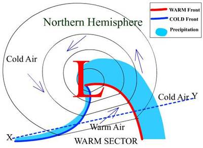
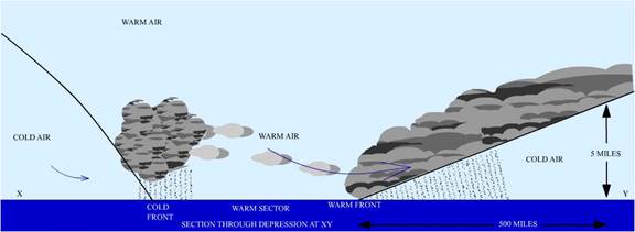
Depression Northern Hemisphere:
Warm air is lighter than cold air and rises over the
cold air ahead of the warm front as shown in the diagram:
This causes
condensation of the water vapour in the warm air, forming at first cloud and
later drizzle or continuous steady rain. The cloud spreads out ahead of the
warm front and the highest cloud, cirrus, is often about 500 miles ahead of it.
At the rear boundary of the warm sector, known as the cold front, the cold air
is pushing under the warm air forcing the latter to ascend rapidly.
This process is sometimes violent enough to produce
squalls. The rapid ascent of the warm air causes the moisture to condense in
the form of cumulonimbus clouds (shower clouds), from which heavy showers may
fall.
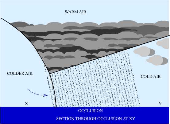
OCCLUSION
The cold front moves faster than the warm front and
gradually overtakes it, causing the warm air to be lifted up from the
surface. When this happens the
depression is said to be occluded and the fronts have merged into a single
front, known as an occlusion.
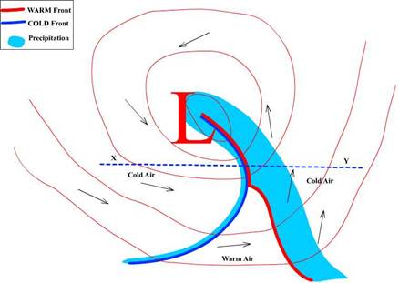
Occlusion Northern Hemisphere:
Occlusion Northern Hemisphere:
FRONT
If two air masses from different regions, such as the
polar and tropical regions, are brought together, the surface boundary where
they meet is known as a front. Further there is a tendency for waves to form on
this front and some of these waves develop into depressions.
This is
shown in the diagram below:
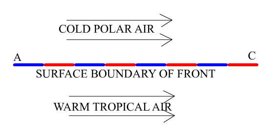
After sometime this surface boundary slowly takes the
form of a depression and has a circulation.
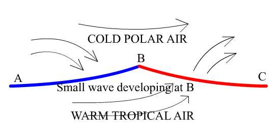
The part of the front marked AB is called a cold front
as along it cold air is replacing warm air. The part marked BC is the warm
front since along this front warm air is replacing cold air.
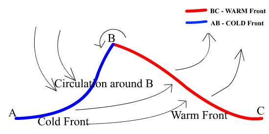
Oceanic
depressions usually have one or more fronts extending from their
centres, each front representing a belt of bad weather, ac companied by a veer
(backing) of wind, which marks the change from the weather characteristic of
one air mass to that of the other. During the first two or three days of its
existence a depression has a warm and a cold front, the area between the two
being known as the warm sector because the air has come from a warmer locality
than that which is outside the sector.
This is shown in the following diagram:
Depression Northern Hemisphere:

Warm air is lighter than cold air and rises over the
cold air ahead of the warm front as shown in the diagram:
These are intense depressions occurring in tropical
latitudes accompanied by high winds and heavy seas. Although the pressure at
the centre of a tropical storm is comparable to that of an intense mid-
latitude depression, the diameter of a tropical storm is much smaller (some 500
miles compared with 1,500 miles), and therefore the pressure gradients and the
wind speeds correspondingly greater.