| Wind Pressure Sys. | Structure of a Depression | Anticyclone | Weather Services | TRS |
Meteorology
Wind
Wind
Because of the rotation of the earth, air, which is
drawn towards a centre of low pressure, is deflected to the right in the N
hemisphere and to the left in the S hemisphere.
The result is an anti-clockwise circulation of wind around an area of
low pressure in the N hemisphere and a clockwise circulation in the S
hemisphere. Circulations around areas of
low pressure are termed cyclonic.
Conversely, the wind circulates in a clockwise
direction around an area of high pressure in the N hemisphere and in an
anti-clockwise direction in the S hemisphere, such circulations being termed
anticyclone.
The strength of the wind at any given time depends
upon the pressure gradient, i.e. on the spacing of the isobars. Isobars are lines which join together places
which at the same time have equal barometric pressure (reduced to sea level)
and are analogous to the contour lines of a map; the closer they are together
the greater the pressure gradient and the stronger the resulting wind.
Surface friction has two effects on the
wind. Firstly it causes a reduction in
the strength of the wind at the surface and secondly it causes the wind to be
deflected some 10° to 20° across the isobars, inwards towards the centre of low
pressure or outwards away from the centre of high pressure.
Buys Ballot’s Law sums this up as follows:
If you face
the wind the centre of low pressure will be from 90° to 135° on your right hand
in the N hemisphere, and on your left hand in the S
hemisphere.
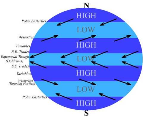
The diagram below shows the distribution of pressure
and the winds, which would result over a featureless earth.
The effect
of the distribution of land and sea
The effect of large landmasses is to modify
considerably the areas of pressure and the wind, as shown in the diagram. The belts of high-pressure around 30°N and
30°S are split into separate cells of high pressure (anticyclones) situated
over the E part of each of the oceans.
The belt of low pressure around 60°N is similarly
modified into separate areas of low pressure situated near
In the S hemisphere there is little or no land in the
area covered by this low-pressure belt and consequently it extends almost
without interruption around the earth.
Superimposed upon these modifications there is a
tendency for pressure to become relatively high over landmasses in the winter
and relatively low in the summer. Such
seasonal changes in pressure distribution can produce large-scale modifications
to winds over neighbouring oceanic regions, a notable example being the monsoon
wind circulation over the
Effects of variations in the
sun’s declination. The annual
movement of the sun in declination causes the belts of pressure and their
associated winds to move towards each pole during its summer.
This oscillation amounts to some 4° of latitude and it
lags some 6 to 8 weeks behind the sun.
The Equatorial Trough (Doldrums) is an area of low
pressure situated between the Trade Winds of the two hemispheres.
Characteristic features of this area are light and
variable winds alternating with squalls, heavy rain and thunderstorms.
The Trough varies greatly in width both daily and
seasonally. The type of weather
experienced also varies considerably.
At times a ship may cross the Trough and experience
fine weather, while on another crossing squalls and thunderstorms may be
encountered.
Weather in the Trough is generally worst when the
Trades are strongest.
This is a highly simplified account of an area where
the weather is complicated and not completely understood.
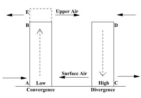
Consider the two columns of air AB and CD in the
figure.
These are of equal cross sectional area, height and
temperature, so that the pressures at A and C are equal, as are those at B and
D.
Suppose the column AB is warmed it will expand to AE,
if the area remains constant, and although the pressure at A will remain
unaltered, the pressure at B will have increased relative to that at D, and to
equalize these air will flow from B to D. This transfer of air from column AB
to CD will cause a drop in pressure at A and a rise at C,
and air will now flow from C to A.
This illustrates the vertical circulation of air in
that the out flowing or diverging air from C is replaced by subsidizing air
from above, whilst the inflowing or converging air at A escapes to the upper
levels and there completes the circulation back to D.
The rate of flow of air from C to A will depend on the
pressure gradient between C and A.
The movement of air straight from a high pressure to a
low pressure only occurs either very close to the equator or in places where
the high and low-pressure areas are small and their centres are near to each
other. Elsewhere, due to the rotation of the earth, there is a deflective
force, which prevents the air flowing directly from high pressure to low. This
force is known as the GEOSTROPHIC or CORIOLIS force
It must be emphasized that for the GEOSTROPHIC wind
which blows at and above 600m, the surface wind speed is about 2/3 that of the
geostrophic wind.
It is useful to know that for equal pressure gradients
the wind velocity in the tropics (lat. 15°) is tree times as great as that in temperate latitudes (52°)
If the isobars are curved as in a high or low-pressure
area, a further force will come into being.
This force, an outward force from the centre of high
or low pressure is called the CYCLOSTROPHIC FORCE.
The angle, which the wind makes with the
isobars, is known as the ANGLE OF INDRAUGHT.
The direction of the true wind should be noted in the
logbook and in weather messages.
It may be estimated by noting the direction of the
waves.
The approximate speed of the wind may be estimated
from the appearance of the sea (see Beaufort scale).
The apparent wind direction and the speed is the
resultant of the ship’s course and speed and the true wind direction and speed.
If any two of the foregoing are known the third can be found by plotting a
triangle of velocities.
Example:
Vessel Course: 022.5°(T) Speed: 11.5k
Apparent Wind: 6 points on the port bow - 067.5° Speed: Estimated at 15k
Required true wind direction
and speed.
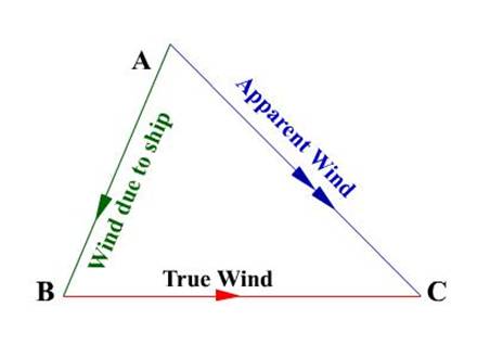
AB represents the ship’s course and speed – this also
represents the apparent wind caused by the movement of the ship, thus the
arrowhead is in opposite direction to the course.
AC represents the apparent wind direction and speed. A
double arrowhead is marked on this since this is the resultant of the true wind
and the wind caused by the movement of the ship.
Joining the points B to C would give the true wind
direction and the distance resolved would give the speed of the true wind
Thus for the example above
we would have a true wind – West and speed of 15k.
WIND ROSES arc found on climatological charts and they
depict the frequency and strength of the winds, blowing from the various
directions. There are many forms of wind
rose, each having its own features.
The following is a Baillie Rose, which is
comprehensive and simple.
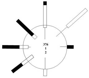
From the circle to the inner end of the wind arrow
represents a scale of 5%. A thin line
represents wind force 1 - 3; a double line represents forces 4 - 7, and a broad
line force 8 upwards. The figures in the
centre show the number of observations, the percentage frequency of variables
and the percentage frequency of calms in that order.
Thus the figure shows North winds 4% light, 10%
moderate and 2% gales;
NE Winds 10% light, 9%-moderate
E winds 5% light, 4% gales
S winds 5% light, 5% moderate
SW winds 6% moderate, 7% gales
W winds, 2% light, 4% moderate, 9% gales
NW winds 3% moderate, 12% gales.
The total number of observation is 376, the frequency
of variables is 1% and there is a 2% frequency of calms.
Beaufort
Wind Scale
|
Beaufort Scale Number |
Wind limit of wind speed (knots) |
Description & Sea Criterion |
|
1 |
Light air 1-3k |
Ripples with the appearance of scales are formed but without foam crests. |
|
2 |
Light breeze 4-6k |
Small wavelets, still short but more pronounced, crests have a glassy appearance and do not break. |
|
3 |
Gentle breeze 7-10k |
Large wavelets. Crests begin to break. Foam of glassy appearance. Perhaps scattered white horses. |
|
4 |
Moderate breeze 11- 16k |
Small waves, becoming longer; fairly frequent white horses. |
|
5 |
Fresh breeze 17-21k |
Moderate waves, taking a more pronounced long form; many white horses are formed. (Chance of some spray). |
|
6 |
Strong breeze22-21k |
Large waves be-gin to form; the white foam crests arc more extensive everywhere (probably some spray). |
|
7 |
Near gale 28-33k |
Sea heaps up and white foam from breaking waves begins to be blown in streaks along the direction of the wind. (spindrift begins to be seen). |
|
8 |
Gale 34-40k |
Moderately high waves of greater length; edges of crests break into spindrift. The foam is blown in well-marked streaks along the direction of the wind. |
|
9 |
Strong gale 41- 47k |
High waves. Dense streaks of foam along the direction of the wind. Sea begins to roll. Spray may affect visibility. |
|
10 |
Storm 48-55k |
High waves with long overhanging crests. The resulting foam in great patches is blown in dense white streaks along the direction of the wind. On the whole the surface of the sea takes a white appearance. The rolling of the sea becomes heavy and shock like. Visibility is affected. |
|
11 |
Violent storm 56-63k |
Exceptionally high waves. (Small and medium-size ships might be for a time lost to view behind the waves). The sea is completely covered with long white patches of foam lying along the direction of the wind. Everywhere the edges of the wave crests are blown into froth. Visibility Affected. |
|
12 |
Hurricane 64-71k |
The air is filled with foam and spray. Sea completely white with driving spray.; visibility very seriously affected. |
There is an extended scale for exceptional wind as
follows
|
Force |
Knots |
|
13 |
72
- 80 |
|
14 |
81
- 89 |
|
15 |
90
– 99 |
|
16 |
100-109 |
|
17 |
110-118 |