| Wind Pressure Sys. | Structure of a Depression | Anticyclone | Weather Services | TRS |
Meteorology
Visibility
FOG
FOG occurs when visibility is reduced to less than
1000 meters, due to the below mentioned causes:
Fog is caused by the cooling of air in contact with
the surface to a temperature at which it can no longer maintain, in an invisible
state, the water vapour, which is present in it. Condensation of this vapour into minute,
though visible, droplets produces fog.
The type of fog depends upon the means by which the air is cooled. For details of specific areas, the Sailing
Directions should be consulted.
Sea or Advection Fog is associated with moist and
relatively warm air flowing over a cold sea surface and is the main type of fog
experienced at sea.
This occurs over the sea when warm tropical maritime
air is cooled below its dew point by conduction from a cold sea surface.
It is most common in the late spring and early summer,
when sea temperature is at its lowest compared with air temperature. To produce fog by this means the rate of
cooling of the air must be high. This only
occurs frequently and on a large scale, either near cold
currents and at a season when the prevailing wind transports warm, moist
air over them, or elsewhere where the sea temperature is appreciably ably lower
than that of the air which blows over land.
The likelihood of fog occurring may be judged if
graphs of the air dew point temperatures and the sea temperatures are drawn and
plotted against time. In the graph below
fog is likely to occur about 2000 hours, if the present trends are
maintained. A change of course to the
southward would alter conditions considerably.
In general terms fog is likely to occur if tropical
maritime air crosses seven sea isotherms from its source.
Sea fog occurs mainly in the summer months where the
areas have cold sea currents flowing through them.
Examples of the former are the fogs, which occur off
Newfoundland, off California and between Japan and the Aleutian Islands; the
cold currents involved being the Labrador, California and Oya
Shio, respectively.
The latter type is represented by the spring and
summer fop in the SW approaches to the English Channel. Aids to forecasting sea fog are given later.
Frontal Fog may occur near an occlusion or ahead of a
warm front and is due to the evaporation of the warm raindrops into the cold
air beneath the frontal surface raising the relative humidity to saturation
point. It occurs in temperate and high
latitudes and is confined to a relatively narrow belt not usually more than 50
miles in width.
Arctic Sea Smoke, or Frost Smoke, is normally confined
to high latitudes and occurs when very cold air flows over a much warmer sea
surface, when intense evaporation takes place from the relatively warm
sea.
The moisture thus evaporated is immediately chilled by
contact with the cold air and condensed to form fog, giving the sea the
appearance of steaming. This type of fog
is often encountered where a cold wind is blowing off ice or snow on to a
relatively warm sea. This frequently occurs in winter over rivers and also off
the East Coasts of continents.
RADIATION FOG
Occurs over land at night when radiation from the
earth has cooled its surface to below the dew point of the air adjacent to it.
Conduction cools this air until condensation takes place. Slight turbulence (wind 3-7 knots) will carry
this cold saturated air to higher levels and will bring to the surface drier
air, which will in turn be cooled and saturated. As the process continues the whole lower
layer of air will become saturated. Radiation Fog forms over low-lying land on
clear nights (conditions for maximum radiation) especially during winter
months. Radiation fog is thickest during
the latter part of the night and early part of the day. Occasionally it drifts out to sea but is
found no farther than 10 to 15 miles offshore as the sea surface temperature is
relatively high which causes the water droplets to evaporate.
A temperature inversion is often associated with
radiation fog, which, acting as a lid keeps the fog low down and causes it to
thicken.
Stronger winds will disperse the fog as will the heat
from the sun.
This type of fog may occur on the banks of rivers and
usually disperses in the morning daylight.
Forecasting sea fog. Warnings of the likely formation of sea fog
may be obtained by frequent observations of air and sea surface temperature; if
the sea surface temperature falls below the dew point, fog is almost certain to
form.
The following procedure is recommended whenever the
temperature of the air is higher than, or almost equal
to that of the sea, especially at night when approaching fog cannot be seen
until shortly before entering it.
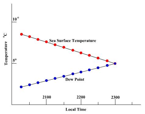
Sea and air (both dry and wet bulb) temperatures
should be observed at least every minutes and the sea surface temperature and dewpoint temperature plotted against time.
If the curves converge fog may be expected when they
coincide. The example shows that by 2200 there is a probability of running into
fog about 2300, assuming that the sea surface temperature continues to fall at
the same rate.
A reliable warning of fog will be given when the dewpoint is within 5°C of the sea surface temperature.
To avoid fog a course should be set for warmer waters.