| Load Lines | Rudder & Propeller |
Ship Construction
Load Lines and Draught Marks
Deck line
The deck line is a horizontal line 300 millimetres in
length and 25 millimetres in breadth. It shall be marked amidships on each side
of the ship, and its upper edge shall normally pass through the point where the
continuation outwards of the upper surface of the freeboard deck intersects the
outer surface of the shell, provided that the deck line may be placed with
reference to another fixed point on the ship on condition that the freeboard is
correspondingly corrected. The location of the reference point and the
identification of the freeboard deck shall in all cases be indicated on the
International Load Line Certificate (1966).
Freeboard. The freeboard assigned is the
distance measured vertically downwards amidships from the upper edge of the
deck line to the upper edge of the related load line.
Freeboard deck. The freeboard deck is normally the
uppermost complete deck exposed to weather and sea, which has permanent means
of closing all openings in the weather part thereof, and below which all the
openings in the sides of the ship are fitted with permanent means of watertight
closing. In a ship having a discontinuous freeboard deck, the lowest line of
the exposed deck and the continuation of that line parallel to the upper part
of the deck is taken as the freeboard deck. At the
option of the owner and subject to the approval of the Administration, a lower
deck may be designated as the freeboard deck, provided it is a complete and
permanent deck continuous in a fore and aft direction at least between the
machinery space and peak bulkheads and continuous athwartships. When this lower
deck is stepped the lowest line of the deck and the continuation of that line
parallel to the upper part of the deck is taken as the freeboard deck. When a
lower deck is designated as the freeboard deck, that part of the hull which
extends above the freeboard deck is treated as a superstructure so far as
concerns the application of the conditions of assignment and the calculation of
freeboard. It is from this deck that the freeboard is calculated.
Load Line Mark
The Load Line Mark shall consist of a ring 300
millimetres in outside diameter and 25 millimetres wide which is intersected by
a horizontal line 450 millimetres in length and 25 millimetres in breadth, the
upper edge of which passes through the centre of the ring. The centre of the
ring shall be placed amidships and at a distance equal to the assigned
summer freeboard measured vertically below the upper edge of the deck line.
The Load line rules which were brought in were due to
the fact that the ships were being loaded in such a way that the ships were
foundering.
Thus the important fact to remember is that it was the
freeboard that was being restricted, from very low to a safe figure.
Depending on this freeboard the load line circle was
marked as well as the other marks were made for different zones and densities.
Thus the chapter on CONDITIONS OF ASSIGNMENT OF FREEBOARD is very important as it
determines as to how much would be the distance between the deck line and the
load line circle.
Once this is determined the load line marks are
painted, keeping the above in reference.
The calculations give rise to the assigned summer
freeboard.
Lines to be used with the Load Line Mark
The lines which indicate the load line assigned in
accordance with these Regulations shall be horizontal lines 230 millimetres in
length and 25 millimetres in breadth which extend forward of, unless expressly
provided otherwise, and at right angles to, a vertical line 25 millimetres in
breadth marked at a distance 540 millimetres forward of the centre of the ring.
The following load lines shall be used:
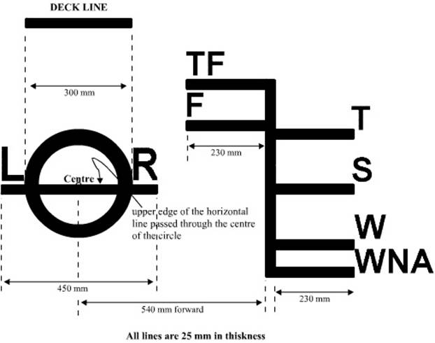
(a) The Summer Load Line indicated by the upper edge
of the line which passes through the centre of the ring and also by a line
marked S.
(b) The Winter Load Line indicated by the upper edge
of a line marked W.
(c) The Winter North Atlantic Load Line indicated by
the upper edge of a line marked WNA.
(d) The Tropical Load Line indicated by the upper edge
of a line marked T.
(e) The Fresh Water Load Line in summer indicated by
the upper edge of a line marked F. The Fresh Water Load Line in summer is
marked abaft the vertical line. The difference between the Fresh Water Load
Line in summer and the Summer Load Line is the allowance to be made for loading
in fresh water at the other load lines.
(f) The Tropical Fresh Water Load Line indicated by
the upper edge of a line marked TF, and marked abaft the vertical line.
If timber freeboards are assigned in accordance with
these Regulations, the timber load lines shall be marked in addition to
ordinary load lines. These lines shall be horizontal lines 230 millimetres in
length and 25 millimetres in breadth which extend abaft unless expressly provided
otherwise, and are at right angles to, a vertical line 25 millimetres in
breadth marked at a distance 540 millimetres abaft the centre of the ring.
The following timber load lines shall be used:
(a) The Summer Timber Load Line indicated by the upper
edge of a line marked LS.
(b) The Winter Timber Load Line indicated by the upper
edge of a line marked LW.
(c) The Winter North Atlantic Timber Load Line
indicated by the upper edge of a line marked LWNA
(d) The Tropical Timber Load Line indicated by the upper
edge of a line marked LT.
(e) The Fresh Water Timber Load Line in summer
indicated by the upper edge of a line marked LF and marked forward of the
vertical line.
The difference between the Fresh Water Timber Load
Line in summer and the Summer Timber Load Line is the allowance to be made for
loading in fresh water at the other timber load lines.
(f) The Tropical Fresh Water Timber Load Line
indicated by the upper edge of a line marked LTF and marked forward of the
vertical line.
Where the characteristics of a ship or the nature of
the ship’s service or navigational limits make any of the seasonal lines
inapplicable, these lines may be omitted.
Where a ship is assigned a greater than minimum
freeboard so that the load line is marked at a position corresponding to, or
lower than, the lowest seasonal load line assigned at minimum freeboard in
accordance with the present Convention, only the Fresh Water Load Line need be
marked.
On sailing ships only the Fresh Water Load Line and
the Winter North Atlantic Load Line need be marked.
Where a Winter North Atlantic Load Line is identical
with the Winter Load Line corresponding to the same vertical line, this load
line shall be marked W.
Additional load lines required by other international
conventions in force may be marked at right angles to and abaft the vertical
line specified in paragraph (1) of this Regulation.
Mark of assigning authority
The mark of the Authority by whom the load lines are
assigned may be indicated alongside the load line ring above the horizontal
line which passes through the centre of the ring, or above and below it. This
mark shall consist of not more than four initials to identify the Authority’s
name, each measuring approximately 115 millimetres in height and 75 millimetres
in width.
Details of marking
The ring, lines and letters shall be painted in white
or yellow on a dark ground or in black on a light ground. They shall also be
permanently marked on the sides of the ships to the satisfaction of the
Administration. The marks shall be plainly visible and, if necessary, special
arrangements shall be made for this purpose.
ZONES,
AREAS AND SEASONAL PERIODS
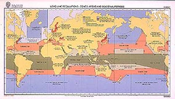
The zones and areas are, in general, based on the
following criteria:
Summer - not more
than 10 per cent winds of force 8 Beaufort (34 knots) or more.
Tropical - not more
than 1 per cent winds of force 8 Beaufort (34 knots) or more. Not more than one
tropical storm in 10 years in an area of 5 square in any one separate calendar
month.
In certain special areas, for practical reasons, some
degree of relaxation has been found acceptable.
Tropical Zone
(1) Northern
boundary of the Tropical Zone
The northern boundary of the Tropical Zone is- the parallel of latitude 13N from the east coast of the American continent to longitude 60W, thence the rhumb line to the point latitude 10N longitude 58W, thence the parallel of latitude 10N to longitude 20W, thence the meridian of longitude 20W to latitude 30N and thence the parallel of latitude 30N to the west coast of Africa; from the east coast of Africa the parallel of latitude 8N to longitude 70E, thence the meridian of longitude 70E to latitude 13N, thence the parallel of latitude 13N to the west coast of India; thence the south coast of India to latitude 1030’N on the east coast of India, thence the rhumb line to the point latitude 9N, longitude 82E, thence the meridian of longitude 82E to latitude 8N, thence the parallel of latitude 8N to the west coast of Malaysia, thence the coast of South-East Asia to the east coast of Vietnam at latitude 10N, thence the parallel of latitude 10N to longitude 145E, thence the meridian of longitude 145E to latitude 13N and thence the parallel of latitude 13N to the west coast of the American continent.
(2) Southern
boundary of the Tropical Zone
The southern boundary of the Tropical Zone is- the
rhumb line from the Port of Santos, Brazil, to the point where the meridian of
longitude 40W intersects the Tropic of Capricorn; thence the Tropic of
Capricorn to the west coast of Africa; from the east coast of Africa the
parallel of latitude 20S to the west coast of Madagascar, thence the west and
north coasts of Madagascar to longitude 50E, thence the meridian of longitude
50E to latitude 10S, thence the parallel of latitude 10S to longitude 98E,
thence the rhumb line to Port Darwin, Australia, thence the coasts of Australia
and Wessel Island eastwards to Cape Wessel, thence the parallel of latitude 11S to the west
side of Cape York; from the east side of Cape York the parallel of latitude 11S
to longitude 150W, thence the rhumb line to the point latitude 26S, longitude
75W, and thence the rhumb line to the west coast of the American continent at latitude
30S.
Coquimbo and
(3) Areas to be
included in the Tropical Zone
The following areas are to be treated as included in
the
(a) The
(b) The
(c) The area bounded by the parallel of latitude 22S
from the east coast of Australia to the Great Barrier Reef, thence the Great
Barrier Reef to latitude 11S. The northern boundary of the area is the southern
boundary of the Tropical Zone.
Seasonal Tropical Areas
The following are Seasonal Tropical Areas:
(1) In the
An area bounded-
on the north by the rhumb line from Cape Catoche, Yucatan, to Cape San Antonio, Cuba, the north
coast of Cuba to latitude 20N and thence the parallel of latitude 20N to
longitude 20W;
on the west
by the coast of the American continent;
on the south
and east by the northern boundary of the Tropical Zone.
Seasonal periods:
TROPICAL: 1 November to 15 July
SUMMER: 16 July to 31 October.
(2) In the
An area bounded-
on the west by the coast of Africa, the meridian of
longitude 45E in the Gulf of Aden, the coast of South Arabia and the meridian
of longitude 59E in the Gulf of Oman;
on the north
and east by the coasts of
on the south
by the northern boundary of the Tropical Zone.
Seasonal periods:
TROPICAL: 1 September to 31 May
SUMMER: 1 June to 31 August.
(3) In the
The
Seasonal periods:
TROPICAL: 1 December to 30 April
SUMMER: 1 May to 30 November.
(4) In the
(a) An area bounded-
on the north
and west by the southern boundary of the Tropical Zone and the east coast of
on the south
by the parallel of latitude 20S;
on the east
by the rhumb line from the point latitude 20S, longitude 50E, to the point
latitude 15S, longitude 5130’E, and thence by the meridian of longitude 5130’E
to latitude 10S.
Seasonal periods:
TROPICAL: 1 April to 30 November
SUMMER: 1 December to 31 March.
(b) An area bounded-
on the north
by the southern boundary of the Tropical Zone;
on the east
by the coast of
on the south
by the parallel of latitude 15S from longitude 5130’E, to longitude 120E and
thence the meridian of longitude 120E to the coast of
on the west
by the meridian of longitude 5130’E.
Seasonal periods:
TROPICAL: 1 May to 30 November
SUMMER: 1 December to 30 April.
(5) In the
An area bounded-
on the west
and north by the coasts of
on the east by the rhumb line from Hong Kong to the
Port of Sual (Luzon Island) and the west coasts of
the Islands of Luzon, Samar and Leyte
to latitude 10N;
on the south
by the parallel of latitude 10N.
Seasonal periods:
TROPICAL: 21 January to 30 April
SUMMER: 1 May to 20 January.
(6) In the North
Pacific
(a) An area bounded-
on the north
by the parallel of latitude 25N;
on the west
by the meridian of longitude 160E;
on the south
by the parallel of latitude 13N;
on the east
by the meridian of longitude 130W.
Seasonal periods:
TROPICAL: 1 April to 31 October
SUMMER: 1 November to 31 March.
(b) An area bounded-
on the north
and east by the west coast of the American continent;
on the west
by the meridian of longitude 123W from the coast of the American continent to
latitude 33N and by the rhumb line from the point latitude 33N, longitude 123W,
to the point latitude 13N, longitude 105W;
on the south
by the parallel of latitude 13N.
Seasonal periods:
TROPICAL: 1 March to 30 June and
1 November to 30 November
SUMMER: 1 July to 31 October and
1 December to 28/29 February.
(7) In the South
Pacific
(a) The
Seasonal periods:
TROPICAL: 1 April to 30 November
SUMMER: 1 December to 31 March.
(b) An area bounded-
on the north
and east by the southern boundary of the Tropical Zone;
on the south by the Tropic of Capricorn from the east
coast of Australia to longitude 150W, thence by the meridian of longitude 150W
to latitude 20S and thence by the parallel of latitude 20S to the point where
it intersects the southern boundary of the Tropical Zone;
on the west
by the boundaries of the area within the
Seasonal periods:
TROPICAL: 1 April to 30 November
SUMMER: 1 December to 31 March.
Summer Zones
The remaining areas constitute the Summer Zones.
However, for ships of 100 metres (328 feet) and under
in length, the area bounded-
on the north
and west by the east coast of the
on the east by the meridian of longitude 6830’W from the
coast of the United States to latitude 40N and thence by the rhumb line to the
point latitude 36N, longitude 73W;
on the south
by the parallel of latitude 36N;
is a Winter
Seasonal Area.
Seasonal periods:
WINTER: 1 November to 31 March
SUMMER: 1 April to 31 October
Reading
Draughts:
The following figure shows the draught marks between
11m and 12m.
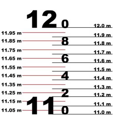
It means that the mark is submerged up to the level of
the mark, measurement of draught being from the bottom up.
When the water is touching exactly the 11M mark at the
bottom, only then is the draught read as 11m. anywhere
above that is more than 11m.
The height of the mark being 20cm, therefore the top
of the 11m mark would read a draught of 11.20 m.
The bottom of the decimal mark of 2 coincides with the
top of the 11M mark and is to be read as 11.20m.
The decimal marks are each 10 cm in height.
Since the decimal marks are at – 2, 4, 5 and 8, the
odd numbered decimal being ignored, thus the top of this 2 would read as 30 cm
above the 11m mark or 11.30m.
If the water level were at a position between the top
of 2 and the bottom of 4 then the reading would be 11.35m.
Rest of the marks are self
explanatory.
If reading the draughts in choppy sea condition then
the average of at least 5 readings would give a reasonable draught. Note do not
read only the highest or the lowest since these may be due to out of the normal
waves.
For loading to draught marks – or when being surveyed
for load line compliance, the draught may be used to check for overloading or
submerging the load line mark. However it should be remembered that it is the
freeboard that is being checked.
For load line surveys the surveyor would mark a long
baton (wooden) with the total length of the freeboard
(summer) and others and then checks with the same against the deck line and the
markings on the shipside (midship marks).